BEYOND FLOOD SUSCEPTIBILITY MAPPING: INTEGRATING GIS, REMOTE SENSING AND MACHINE LEARNING FOR FLOOD-RISK ASSESSMENT IN NIGERIA 0 0
DOI:
https://doi.org/10.83374/jesber.vol1no2.93Keywords:
Flood susceptibility, Flood-risk assessment, Geographic Information Systems (GIS), Remote sensing, Machine learning, GeoAI, Vulnerability assessment, NigeriaAbstract
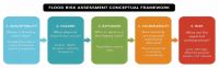
Flooding is a persistent environmental hazard in Nigeria, affecting settlements, infrastructure, agriculture, and livelihoods. Geographic Information Systems (GIS), remote sensing, and Machine Learning (ML) have improved the identification of flood-prone locations and the prediction of spatial flood patterns, yet a recurrent conceptual problem remains: a flood-susceptibility map is not, by itself, a flood-risk assessment. This paper presents a structured critical review of Nigerian flood studies published principally between 2016 and 2026, evaluating conceptual framing, data sources, modelling methods, and treatment of hazard, exposure, vulnerability, and uncertainty. The review finds that the literature has evolved from GIS-based multi-criteria mapping through statistical and ML modelling to event-scale satellite mapping and emerging integrated GeoAI approaches, with technical capability advancing faster than risk integration: many studies still estimate relative spatial propensity while omitting inundation depth, exposed assets, social vulnerability, and consequence. The review's main contribution is an operational framework in which dominant flood processes are diagnosed before modelling, hazard is characterised from satellite and hydrodynamic evidence, and susceptibility is explicitly linked to exposure, vulnerability, and future climate and land-use change. Future Nigerian flood studies should be judged not only by predictive accuracy, but also by physical plausibility, generalisability, uncertainty communication, and usefulness for planning.Downloads
References
Abubakar, A., Sani, M., Ahmad, M. H., & Gambo, J. (2025). Geospatial flood risk mapping and vulnerability assessment using GIS and AHP in Hadejia River Basin, Jigawa State, Nigeria. FUDMA Journal of Sciences, 9(12), 4323. https://doi.org/10.33003/fjs-2025-0912-4323
Ajibade, F. O., Ajibade, T. F., Idowu, T. E., et al. (2021). Flood-prone area mapping using GIS-based analytical hierarchy frameworks for Ibadan city, Nigeria. Journal of Multi-Criteria Decision Analysis, 28(5-6), 283–295. https://doi.org/10.1002/mcda.1759
Alfa, M. I., Ajibike, M. A., & Daffi, R. E. (2018). Application of Analytic Hierarchy Process and Geographic Information System techniques in flood risk assessment: A case of Ofu River Catchment in Nigeria. Journal of Degraded and Mining Lands Management, 5(4), 1363–1372. https://doi.org/10.15243/jdmlm.2018.054.1363
Amama, S. A., Arokoyu, S. B., & Obafemi, A. A. (2023). Spatial assessment of the relationship between social vulnerability and resilience to flooding in the Core Niger Delta, Nigeria. International Journal of Research and Innovation in Social Science, 7(10). https://doi.org/10.47772/IJRISS.2023.701048
Aniramu, O., Iyanda, O., & Orimoogunje, O. (2026). Remote sensing and GIS-based modelling of land use dynamics and urban flood risk in Lagos megacity for future flood mitigation. Scientific Reports, 16, 8125. https://doi.org/10.1038/s41598-026-38544-1
Bello, M., Singh, S., Singh, S. K., et al. (2024). Geospatial analysis of flood susceptibility in Nigeria's vulnerable coastal states. Climate, 12(7), 93. https://doi.org/10.3390/cli12070093
Chinedu, A. D., Ezebube, N. M., Uchegbu, S., & Ozorme, V. A. (2024). Integrated assessment of flood susceptibility and exposure rate in the Lower Niger Basin, Onitsha, Southeastern Nigeria. Frontiers in Earth Science, 12, 1394256. https://doi.org/10.3389/feart.2024.1394256
Chukwuma, E. C., Okonkwo, C. C., & Ojediran, J. O. (2021). A GIS-based flood vulnerability modelling of Anambra State using an integrated IVFRN-DEMATEL-ANP model. Heliyon, 7(9), e08048. https://doi.org/10.1016/j.heliyon.2021.e08048
Eneyo, V. B. (2026a). Foundations and practice of tourism development. University of Calabar Press.
Eneyo, V. B. (2026b). Foundations of environmental management. University of Calabar Press.
Eteh, D. R., Egobueze, F. E., Paaru, M., Otutu, A., & Osondu, I. (2024). The impact of dam management and rainfall patterns on flooding in the Niger Delta: Using Sentinel-1 SAR data. Discover Water, 4, 123. https://doi.org/10.1007/s43832-024-00185-8
Gambo, J., Roslan, S. N. A. B., Shafri, H. Z. M., et al. (2024). Unveiling and modelling the flood risk and multidimensional poverty determinants using a geospatial multi-criteria approach: Evidence from Jigawa, Nigeria. International Journal of Disaster Risk Reduction, 106, 104400. https://doi.org/10.1016/j.ijdrr.2024.104400
Gilbert, K. M., & Shi, Q. (2026). Interpretable ensemble machine learning for flood susceptibility mapping in Lagos Lagoon, Nigeria. Journal of African Earth Sciences, 240, 106130. https://doi.org/10.1016/j.jafrearsci.2026.106130
Ibrahim, S., & Balzter, H. (2024). Evaluating flood damage to paddy rice fields using PlanetScope and Sentinel-1 data in North-Western Nigeria. Remote Sensing, 16(19), 3657. https://doi.org/10.3390/rs16193657
Idrees, M. O., Yusuf, A., Mokhtar, E. S., & Yao, K. (2022). Urban flood susceptibility mapping in Ilorin, Nigeria, using GIS and multi-criteria decision analysis. Modeling Earth Systems and Environment, 8(4), 5779–5791. https://doi.org/10.1007/s40808-022-01479-3
Ighile, E. H., Shirakawa, H., & Tanikawa, H. (2022). Application of GIS and machine learning to predict flood areas in Nigeria. Sustainability, 14(9), 5039. https://doi.org/10.3390/su14095039
Koko, A. F., Wu, Y., Abubakar, G. A., Hamed, R., & Alabsi, A. A. N. (2021). Analyzing urban growth and land cover change scenario in Lagos, Nigeria using multi-temporal remote sensing data and GIS to mitigate flooding. Natural Hazards, 107, 2085–2107.
Komolafe, A. A., Awe, B. S., Olorunfemi, I. E., & Oguntunde, P. G. (2020). Modelling flood-prone areas and vulnerability using integration of multi-criteria analysis and HAND model in the Ogun River Basin, Nigeria. Hydrological Sciences Journal, 65(10), 1766–1783. https://doi.org/10.1080/02626667.2020.1764960
Njoku, C. G., Efiong, J., Uzoezie, A. C., Okeniyi, F. O., & Alagbe, A. O. (2018). A GIS multi-criteria evaluation for flood risk-vulnerability mapping of Ikom Local Government Area, Cross River State. Journal of Geography, Environment and Earth Science International, 15(2), 1–17. https://doi.org/10.9734/JGEESI/2018/40527
Nkeki, F. N., Bello, E. I., & Agbaje, I. G. (2023). Are the existing methods sustainable? A hybrid approach to flood risk mapping. MethodsX, 11, 102348. https://doi.org/10.1016/j.mex.2023.102348
Okoduwa, K. A., Amaechi, C. F., Biose, E., Omoruyi, C. I., & Henry, B. (2024). Adopting Sentinel-1 SAR data for flood mapping: A case study of Borno State, Northeastern Nigeria. Ethiopian Journal of Environmental Studies and Management, 17(4), 524–538. https://doi.org/10.4314/ejesm.v17i4.9
Okoli, E. A., Maximus, J. K., Agoha, C. C., et al. (2026). Integrated flood susceptibility mapping using machine learning and geospatial techniques: A case study of Imo State, Southeastern Nigeria. Journal of African Earth Sciences, 233, 105872. https://doi.org/10.1016/j.jafrearsci.2025.105872
Rahman, M. T., Ibukun, J. A., Olubaju, A. E., Sodipo, E. O., & Oyetunji, S. O. (2026). Integrating SAR remote sensing and machine learning for comprehensive flood risk assessment in Kogi State, Nigeria. Journal of African Earth Sciences, 241, 106168. https://doi.org/10.1016/j.jafrearsci.2026.106168
Tella, A., & Balogun, A.-L. (2020). Ensemble fuzzy MCDM for spatial assessment of flood susceptibility in Ibadan, Nigeria. Natural Hazards, 104(3), 2277–2306. https://doi.org/10.1007/s11069-020-04272-6
Tella, A., Balogun, A.-L., et al. (2022). Assessment of data mining, multi-criteria decision making and fuzzy-computing techniques for spatial flood susceptibility mapping: A comparative study. Geocarto International, 37(26), 12989–13015. https://doi.org/10.1080/10106049.2022.2076910
Tique, W. F. M., Sapena, M., Weigand, M., Groth, S., Geiß, C., & Taubenböck, H. (2026). A comparative assessment of data-driven flood susceptibility mapping in Nigeria. Natural Hazards, 122, 139. https://doi.org/10.1007/s11069-025-07868-y
Umar, J. J., Adenle, A. A., Asonibare, O. F., & Nwobi, N. O. (2026). Peri-urban flood risk mapping and exposure analysis in Niger State, Nigeria. Discover Hazards, 2, 30. https://doi.org/10.1007/s44475-026-00037-0
Wali, E., Phil-Eze, P. O., Wizor, C. H., et al. (2021). Flood vulnerability assessment on selected communities in Ikwerre Local Government Area of Rivers State, Nigeria, using remote sensing and GIS techniques. Journal of Geography, Environment and Earth Science International, 25(9), 46–57. https://doi.org/10.9734/JGEESI/2021/v25i930308
Downloads
Published
Issue
Section
License
Copyright (c) 2026 Journal of Enviromental Sciences and Built Environental Research

This work is licensed under a Creative Commons Attribution-NonCommercial-ShareAlike 4.0 International License.
All articles are published under Creative Commons Attribution 4.0 International License (CC BY 4.0). Users may share, adapt, and distribute the work provided appropriate credit is given to the authors and JESBER.