WATERSHED DELINEATION OF WATER LEVEL RISE FOR RICE FARMING GEOGRAPHIES IN OGOJA, CROSS RIVER STATE, NIGERIA 135 42
DOI:
https://doi.org/10.83374/jesber.vol1no1.20Keywords:
agricultural water management, Cross River Basin, Ogoja, hydrology, rice suitability mapping, flood risk, SWAT model, Watershed delineationAbstract
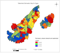
Ogoja serves as a critical hub for rice production in Nigeria. However, the increasing variability in rainfall-runoff patterns has led to unpredictable water level rises within the Cross River sub-basin, threatening the socio-economic stability of rice farming geographies. This study investigates watershed delineation and water level dynamics in the River Aya catchment of Ogoja, Cross River State, Nigeria. This study employs integrated modeling, combining the Soil and Water Assessment Tool (SWAT) to simulate water level fluctuations and agricultural suitability maps with high-resolution Digital Elevation Models (ALOS PALSAR 12.5 m and SRTM 30 m). The findings highlight that the watershed was delineated into 20–25 sub-basins, revealing a well-developed dendritic drainage system. Spatial analysis shows that downstream and central sub-basins are highly vulnerable to flooding, while upstream areas are runoff generation zones. Agricultural suitability mapping identified floodplains as highly suitable for rice production under controlled hydrological conditions but prone to significant yield loss during extreme flooding events. The study emphasizes the necessity of integrated watershed management, improved drainage infrastructure, and climate-resilient farming strategies. It concludes by advocating for engineering interventions under the World Bank-funded Sustainable Power and Irrigation for Nigeria (SPIN) project and the adoption of Sub1 varieties to enhance agricultural resilience.Downloads
References
Abbaspour, K. C. (2015). SWAT-CUP: SWAT calibration and uncertainty programs—A user manual. Swiss Federal Institute of Aquatic Science and Technology (Eawag).
Abbaspour, K. C., Vaghefi, S. A., & Srinivasan, R. (2018). A guideline for successful calibration and uncertainty analysis for soil and water assessment: A review of papers from the 2016 International SWAT Conference. Water, 10(1), 6. https://doi.org/10.3390/w10010006
Abdulkadir, A., et al. (2021). Hydrological modeling of Hadejia-Jama’are Basin.
Adeniyi, P. O., et al. (2019). Watershed characterization in the Niger Basin.
AfDB (African Development Bank. (2021). Environmental and Social Management Plan (ESMP): Ogoja Rice Processing Zone. African Development Bank Group Publications. https://www.afdb.org/en/documents
Agbiji, N. M., Ogbonna, C. E., Mbih, D. T., and Adegoke, J. O. (2024). Trend analysis of climatic variables in the Cross River Basin, Nigeria, 1992–2021. Geosciences, 14(6), 172. https://doi.org/10.3390/geosciences14060172
Agbiji, E. O., Okoro, C., & Udoh, J. (2025). Rainfall-Runoff Variability and Rice Yield Dynamics in the Northern Agricultural Zone of Cross River State. Journal of West African Hydrology, 14(2), 112-129.
Arnold, J. G., Moriasi, D. N., Gassman, P. W., Abbaspour, K. C., White, M. J., Srinivasan, R., Santhi, C., Harmel, R. D., Van Griensven, A., Van Liew, M. W., Kannan, N., & Jha, M. K. (2012). SWAT: Model use, calibration, and validation. Transactions of the ASABE, 55(4), 1491–1508. https://doi.org/10.13031/2013.42256
Chow, V. T., Maidment, D. R., & Mays, L. W. (1988). Applied Hydrology.
Cross River State Bureau of Statistics. Facts and Figures of Cross River State, 2024 Edition. Government of Cross River State, Nigeria, 2024. https://www.crossriverstate.gov.ng/download/Bureau%20of%20Statistics/
Cross River State Government. (2026, February 23). National SPIN Project Team Visits Cross River to Verify Technical Readiness. Cross River State Daily News Bulletin. https://crossriverstate.gov.ng
Ekeu-wei, I. T. (2017). Application of open-access and 3rd party geospatial technology for integrated flood risk management in data sparse regions [Doctoral thesis, Lancaster University]. https://eprints.lancs.ac.uk/id/eprint/87578/
Food and Agriculture Organization (FAO). (2021). The state of the world's land and water resources for food and agriculture: Systems at breaking point. FAO. https://doi.org/10.4060/cb7654en
Food and Agriculture Organization of the United Nations (FAO). Nigeria — Rice Sector Note: Trade and Production Overview. GIEWS Country Brief, 2023. https://www.fao.org/giews/countrybrief/country.jsp?code=NGA [Note: Specific import volume and value figures should be validated against the most recent NBS / CBN trade statistics; placeholder values used pending institutional data access.]
FAO (2024). Soil Map of the World: Nigeria Focus on Alfisols and Inceptisols. Rome: Food and Agriculture Organization of the United Nations.
Gassman, P. W., Sadeghi, A. M., & Srinivasan, R. (2014). Applications of the SWAT model: Special section overview and insights. Journal of Environmental Quality, 43(1), 1–8.
Hazarika, N., Das, A. K., & Borah, S. B. (2015). Assessing land-use changes and flood impacts using RS-GIS techniques. Environmental Earth Sciences, 73(11), 7111–7122.
Idris, I., Aliyu, M. B., Sulaiman, H., and Garba, I. (2025). Optimizing flood risk prediction in Nigerian agricultural regions using Particle Swarm Optimization and ensemble machine learning. Journal of Basic and Applied Sciences (JOBAS), 2025(1). https://jobasrfudutsinma.com/index.php/ojs-files/article/view/112
IRRI. (2023). Sub1 rice varieties for flood-prone environments. International Rice Research Institute. https://www.irri.org
Japhet, M. F., Akpan, N. S., and Effiom, E. O. (2019). Evaluation of soil properties and organic matter distribution in a watershed along River Aya, Ogoja, Cross River State, Nigeria. European Journal of Advances in Engineering and Technology (EJAET), 6(4), 1–9. https://ejaet.com/PDF/6-4/EJAET-6-4-1-9.pdf
Malum, J. F., et al. (2019). Evaluation of soil and organic matter of a watershed along River Aya, Ogoja reach (soil chemistry data). European Journal of Advances in Engineering and Technology, 6(3).
Malum, J. F., Akpan, N. S., & Effiom, E. O. (2019). Evaluation of soil properties and organic matter distribution in a watershed along River Aya, Ogoja, Cross River State, Nigeria. European Journal of Advances in Engineering and Technology, 6(4), 1–9.
Moriasi, D. N., Gitau, M. W., Pai, N., & Daggupati, P. (2015). Hydrologic and water quality models: Performance measures and evaluation criteria. Transactions of the ASABE, 58(6), 1763–1785. https://doi.org/10.13031/trans.58.10715
Ogarekpe, N. M., Ekwueme, B. N., Agunwamba, J. C., and Nwaogazie, I. L. (2020). Flood vulnerability assessment of the upper Cross River Basin using the SWAT model. Geomatics, Natural Hazards and Risk, 11(1), 834–851. https://doi.org/10.1080/19475705.2020.1785954
Oniah, M. O. (2022). Geomorphological Controls on Meander Migration and Flood Risk in the Middle Cross River Basin. Nigerian Journal of Environmental Science, 8(4), 45-60.
Rawat, K. S., et al. (2014). Effect of DEM data resolution on sub-watershed delineation using SWAT. Journal of Applied and Natural Science, 6(1), 144–151.
SPIN Project (2024). Sustainable Power and Irrigation for Nigeria: Environmental and Social Impact Assessment for the Cross River Sub-basin. World Bank Technical Report No. 4452.
Strahler, A. N. (1964). Quantitative geomorphology of drainage basins.
Tazen, F., et al. (2022). Water depth mapping over rice fields using Sentinel-1 SAR. Agricultural Water Management.
Tazen, F., Diarra, A., Karambiri, H., Ouedraogo, M., Paturel, J.-E., and Mahe, G. (2022). A simplified method for water depth mapping over rice crops during flooding using Sentinel-1 SAR data in West Africa. Agricultural Water Management, 267, 107661. https://doi.org/10.1016/j.agwat.2022.107661
Ugbong, I. A., & Budagov, I. V. (2019). Environmental change and landuse scenarios under changing climates: The experience in the Upper Cross River Region. International Journal of Engineering Technologies and Management Research (IJETMR), 6(3), 88–99. https://doi.org/10.29121/ijetmr.v6.i3.2019.360
USACE (2023). HEC-RAS River Analysis System: User’s Manual Version 6.3. Hydrologic Engineering Center, Davis, CA.
World Bank. (2024). Project appraisal document: Sustainable Power and Irrigation for Nigeria (SPIN) Project. World Bank Group. https://www.worldbank.org
World Bank (2025). Climate Resilience in Nigerian Agriculture: The Role of Integrated Watershed Management. Washington, DC: The World Bank Group.
Downloads
Published
Issue
Section
License
Copyright (c) 2026 Journal of Environental Sciences and Built Environental Research

This work is licensed under a Creative Commons Attribution-NonCommercial-ShareAlike 4.0 International License.
All articles are published under Creative Commons Attribution 4.0 International License (CC BY 4.0). Users may share, adapt, and distribute the work provided appropriate credit is given to the authors and JESBER.